Globex Discovers Wide Gold Zones at the Salt Spring Project in Arizona
TORONTO, June 02, 2026 (GLOBE NEWSWIRE) -- GLOBEX MINING ENTERPRISES INC. (GMX – Toronto Stock Exchange, G1MN – Frankfurt, Stuttgart, Berlin, Munich, Tradegate, Lang & Schwarz, LS Exchange, TTMzero, Düsseldorf and Quotrix Düsseldorf Stock Exchanges and GLBXF – OTCQX International in the US) is pleased to provide a summary of past and follow-up exploration efforts by Globex at its Salt Spring Gold Project. The properties main claim block was staked in September 2023 and was expanded by staking in March 2025 and again in March 2026. It is in northwestern Arizona, Mohave County, 85 km southeast of the city of Las Vegas, Nevada. The Salt Spring property now consists now of 57 unpatented lode claims. The property has a total surface area of 471.77 ha.
Highlights of recent Exploration:
- Exploration efforts including soil sampling, trenching and sampling (Dec. 2025 to Jan. 2026) have led to the discovery of several low and high-grade gold occurrences, previously not recognized.
- Grab sample B-111 on anomaly 2 A returned 10.73 g/t Au.
- Strongly anomalous soil sample results in the east block with results as high as 0.9 g/t Au and in the central block with results as high as 0.8 g/t Au.
- Discovered new Zone 3A with 16 channel and chip samples collected and returning a thickness of 17.0 m with an average weighted grade of 1.54 g/t Au from TR-A trench.
- The extension from trench TR-A was confirmed with trench TR-C sampling returning 7.0 m with a weighted average grade of 0.716 g/t Au and thereby increasing the potential width of the gold mineralisation.
The project area is situated at the northernmost margin of the historic Gold Basin mining district. This district is rather large, about 18 km long (N-S) and 7 to 11 km wide. A number of conspicuous major faults and lineaments crosscut the Gold Basin – Lost Basin Mining District. Some might be directly related to gold mineralization. The gold mineralization in the district is not evenly distributed but rather restricted to several distinct gold-corridors.
Gold mineralization in the northern Gold Basin district is confined to a roughly east-west orientated 7 km long corridor, ranging in width between 0.4 km and up to 1 km. Globex’s Salt Spring Property covers this northern gold corridor. Within this corridor are located a great number of historic exploration workings. There were historically 22 small scale mines and at least 70 prospects and cuts found on the property. The largest historic mine was the Gold Hill mine, located in the East claim block. The Gold Hill Mine produced high-grade gold ore intermittently between 1930 and 1942. No production records from the Gold Hill Mine have been found except a note that reports 359.57 t averaging 21.7 g/t Au in 1940.
Regional Geologic Map of the Gold Basin-Lost Basin Mining District, Arizona
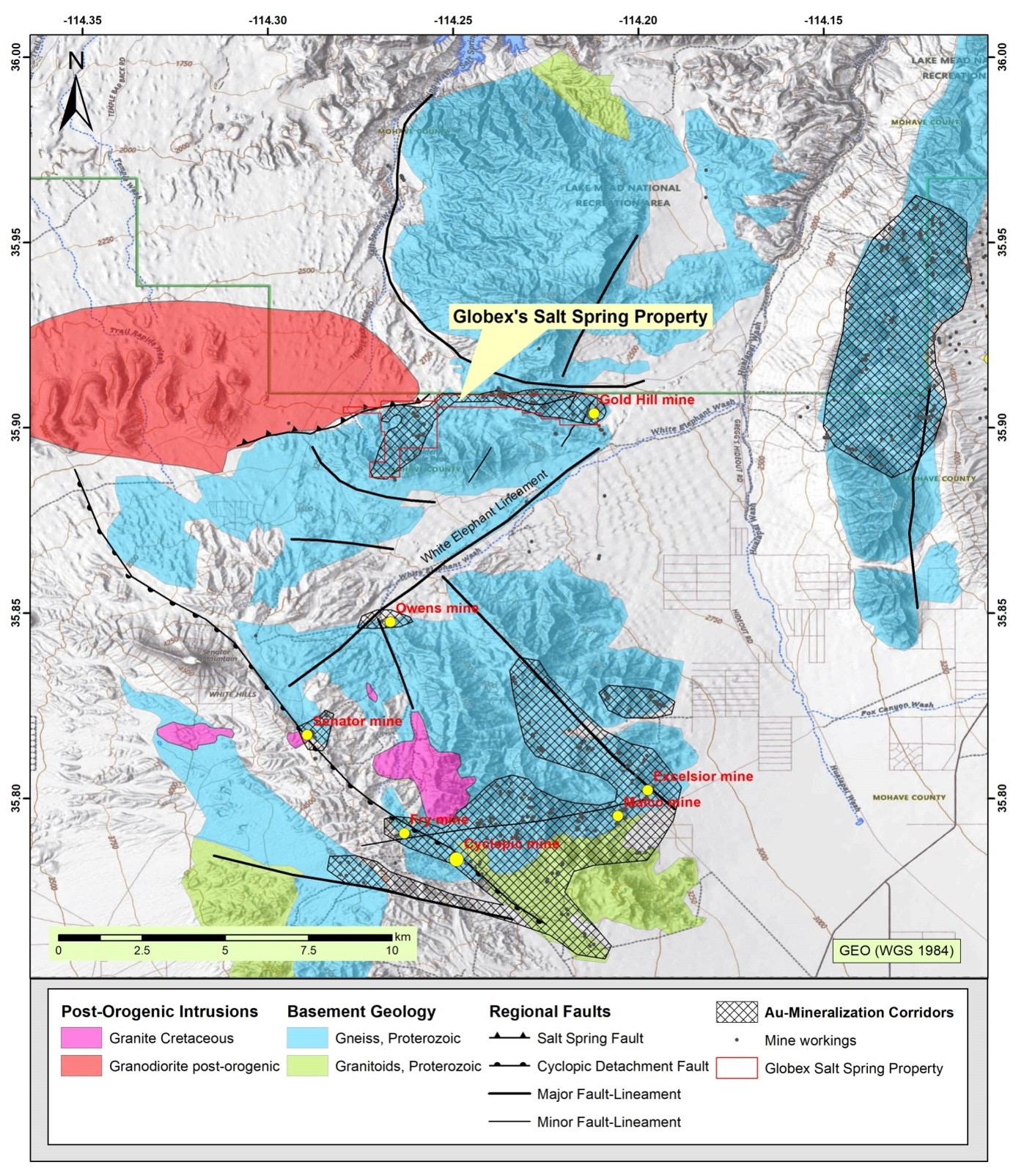
Larger historic Au mines marked as yellow dots. Globex’s Salt Spring Property covers the northernmost about E-W trending gold corridor.
Gold in the district occurs in narrow, partly high-grade mesothermal quartz-carbonate veins, but the bulk is of low-grade hosted in stockwork- and disseminated zones. It is believed that gold deposition occurred in a mesothermal intrusion-related environment, linked to Cretaceous granitoids, although Miocene hydrothermal (epithermal or brines) overprint is indicated as well.
It appears that gold zones in the region are associated with or hosted in small-scale faults that are different in orientation from the regional faults. In general, most auriferous quartz veins have a NW-SE strike meanwhile most regional faults (Salt Spring Fault & White Elephant Fault) trend SW-NE. It is suggested that movement along the regional SW-NE faults has led to many small-scale subsidiary faults and fractures with subsequent gold mineralization.
In summary the gold mineralisation in the Salt Spring project occurs in the following geological environments:
- In steep dipping (> 45°) mesothermal bull quartz veins, with or without significant epithermal quartz overprint. Rarely exclusively in epithermal quartz veins.
- In flat dipping to sub-horizontal shear zones together with abundant (bull, less epithermal) quartz veining (example is Gold Hill mine).
- In flatly dipping to sub-horizontal manto-like shear/breccia zones with little, occasionally without any quartz veining (for example North mine).
- In carbonate (ankerite-siderite) - sericite - (pyrite) altered wallrock with or without quartz veinlets/stockwork attached as envelopes to auriferous quartz veins.
- Disseminated gold in breccias (partly polymictic) and weakly to strongly sheared-foliated gneiss/granite with pervasive sericite-carbonate-(oxidized sulphides) alteration, locally minor mesothermal quartz veinlets and silicification may appear. Major auriferous mesothermal bull quartz veins are absent.
- In coarse grained to pegmatitic granite dikes or feldspar-dominated pegmatite dikes affected by locally intense replacement with coarse crystalline pyrite (oxidized to limonite/hematite). These zones may assay several g/t in gold.
- Disseminated in gneiss, lacking faulting and macroscopically visible alteration.
Exploration Program and Results
Globex carried out preliminary fieldwork in both claim blocks, including geological mapping, soil sampling and collected a total of 111 surface and underground rock samples between 2023 and 2025. Most samples had been collected from historic workings and mine dumps. Based on geology and assay results Globex outlined at total of 11 promising gold target zones, targets A to D & K in the West claim block and targets F to J in the East claim block. A summary of selected assay results of these rocks samples is given in the following table:
Selected Assay Results Salt Spring Project, Rock Samples (2023-2025)
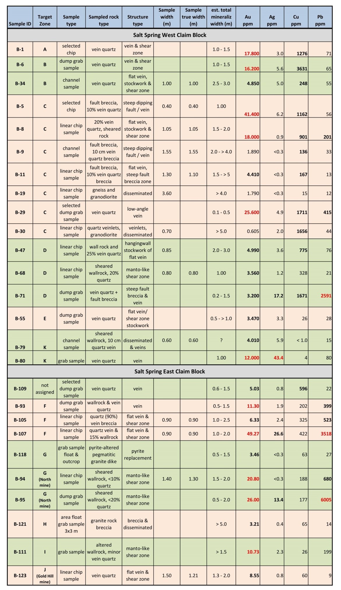
Note: Grab samples and chip samples are selective by nature and are unlikely to be representative of average grades. Conversion 1ppm =1g/t.
Latest exploration efforts (Dec. 2025 to Jan. 2026) lead to the discovery of several low- and high-grade gold occurrences, that had not been recognized in the past (no historic prospect or mines).
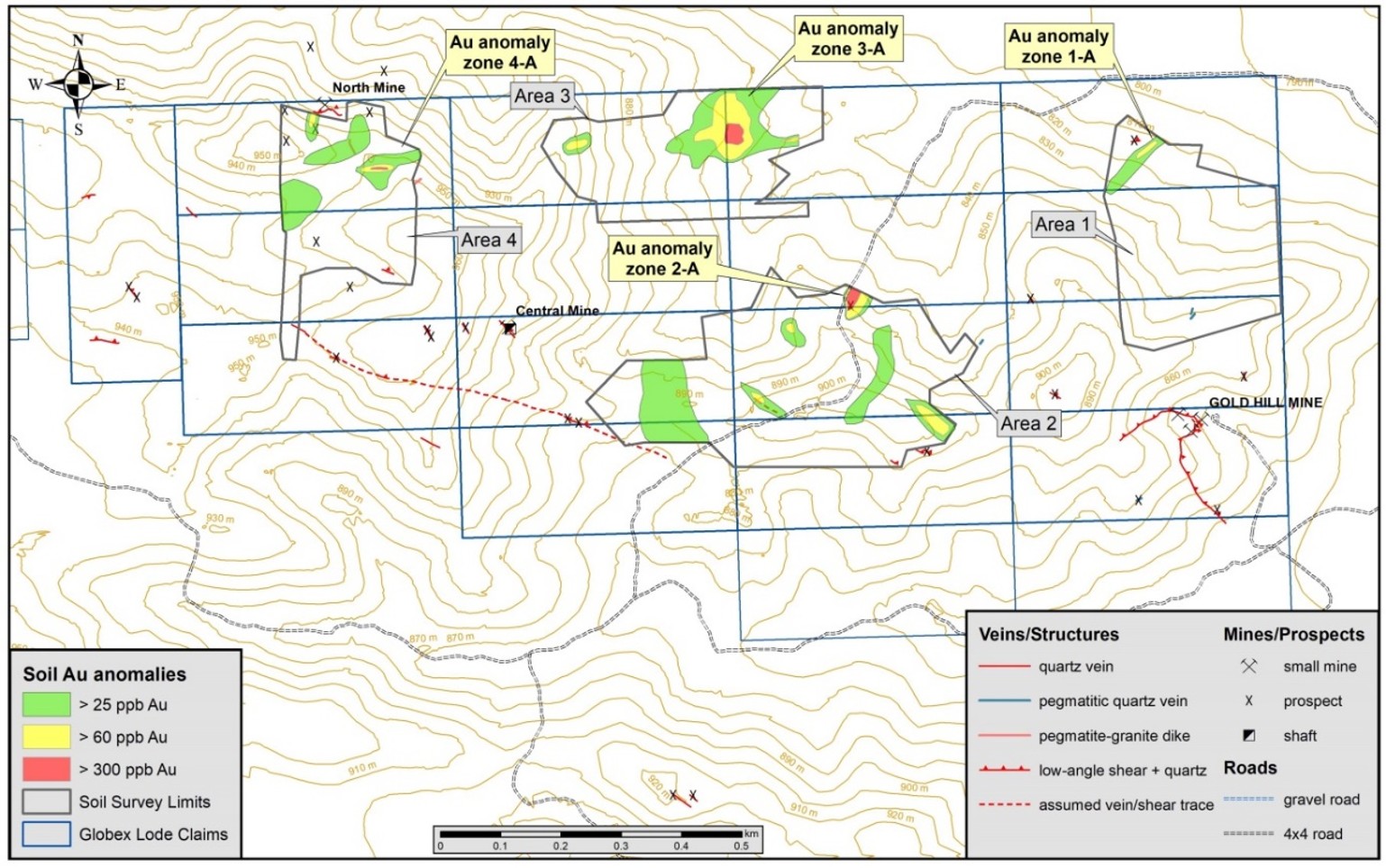
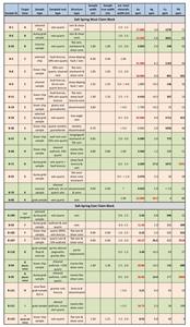
A comprehensive geochemical soil survey was completed in November 2025. A total of 331 soil samples were collected in four selected areas of the East claim block. Assay results for soil samples ranged between less 3 ppb Au (detection limit) to a maximum value of 909 ppb Au (0.9 g/t Au). Gold values in soil samples above 25 ppb are considered anomalous and could be indicative to gold mineralisation concealed under shallow overburden. Most significant gold in soils anomaly zones were Zones 2-A, 3-A and 4-A.
Soil Sample Anomaly Zone 2-A is associated to high-grade gold mineralisation that is source for a small eluvial placer gold deposit in a gulch to the northeast. Rock grab sample B-111 had been collected already here in March 2025, it returned 10.73 ppm Au.
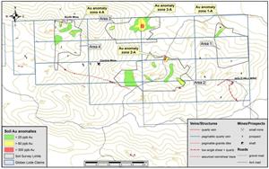
Soil Sample Anomaly Zone 3-A is considered as the most striking target discovery of the entire Globex claim block so far. The gold in soil anomaly > 25 ppb measures 220 m in E-W and 120 m in N-S direction. A central zone with anomalous gold values > 60 ppm measures 110 m in N-S and 90 m in E-W direction. In the core of the anomaly zone three soil samples returned high gold values (353 ppb, 496 ppb and 828 ppb Au), encompassing a circular area with a diameter of about 30 m. Anomaly 3-A could be indicative of gold mineralisation beneath the shallow overburden.
Soil Sample Anomaly Zone 4-A is spatially linked to the southern margin of a large east north east trending granite dike. The anomaly (>25 ppb) is about 100 m long (open to E) and up to 90 m wide. The highly anomalous core zone (2 soil samples) returned up to 411 ppb Au in soil and is about 50 m long.
Globex’s Salt Spring East Claim Block with Gold in Soil Anomaly Zones
The following is a description of only two of the discovered gold occurrences uncovered in follow up trenching and sampling in 2026 including 39 rock samples:
Zone 3-A: There were three trenches dug and sampled in this area. Trench TR-A is centred on the highest gold in soil anomaly zone; it is orientated WNW-ESE and 17 m long. Bedrock at the bottom of the trench included granite, a coarse polymictic clast-supported breccia, faulted/sheared gneiss with carbonate-sericite alteration and fault/shear breccias (partly silicified). A total of 16 channel and linear chip samples were collected continuously from east to west. All samples assayed gold values and the (weighted) average over the entire trench length of 17.0 m is 1.54 g/t Au. A higher-grade interval of 7.0 m length (between 5.0 and 12.0 m) assayed 3.24 g/t Au. Highest grade channel sample B-139 returned 12.70 g/t Au over 1.0 m length. Mineralisation remains open to the ESE. Displaced by 5.0 m to the NW had been excavated trench TR-C over a length of 7.0 m; it is also orientated WNW-ESE. A total of 6 samples had been collected continuously from east to west. All samples assayed gold values and the average over the entire trench length of 7.0 m is 0.716 g/t Au. Highest grades returned the two westernmost samples (each 1.0 m long) B-163 and B-164 with 1.01 and 2.18 g/t Au respectively. Consequently, gold mineralisation remains also open to the west. Trench TR-B over was excavated over a length of 5.65 m did not return any significant gold values. Trenching and assay results confirm that the large gold in soil anomaly Zone 3-A is associated with a low-grade gold zone (with local high-grade) and a minimum width of 24.0 m, and open to both sides and a potential dip of 50 degrees west.
Close-up map of Gold in Soil Anomaly Zone 3-A, Trenches & Assay Results

Zone 4-A: It is spatially associated to an about E-W trending steeply dipping fault/shear in a wide granite dike. Trench TR-D is orientated SSW-NNE, it is 13.0 m long and was sampled over two separate segments totalling a length of 9.60 m. Sampled interval between 8.00 and 10.60 m (B-168 to B-170) assayed 6.21 g/t Au over 2.6 m length. Highest grade returned channel sample B-170 with 13.1 g/t over 0.6 m length. Mineralisation is associated with a fault/shear breccia. Proximal to the high-grade structure are envelopes of very low-grade gold mineralisation. The mineralised shear zone could continue in to both east and west
Analytical Methods
Rock and soil samples were placed in labelled plastic bags, sealed with a plastic zip and shipped to American Assay Laboratories (AAL) in Sparks, Nevada, USA for preparation and geochemical analysis. AAL is an ISO 17025 certified laboratory. Samples are crushed and a 300 g subsample pulverized to >85% -75 micron. All samples underwent ICP-OES analysis of a 0.5 g subsample after 5-acid digestion (HNO3, HF, HClO4, HCl and H3BO3) for 11 elements including silver. 5-acid treatment results in near total digest (resistant phases e.g. corundum, ilmenite, rutile are not digested). Gold was analysed via fire assay of a 30 g subsample and analysed with ICP-OES. Obtained gold values above 10 g/t were re-analysed via fire assay of a 30 g subsample and gravimetric determination. Typical internal standards and checks were completed by AAL during analysis. Soil samples were dried at 60°C and sieved to 80 mesh (0.177 mm). The -80-mesh fraction was analyzed. Gold was analyzed via fire assay of a 30 g subsample and analyzed with ICP-OES.
This press release was written by Matthias Jurgeit, Eurogeologist under the supervision of Jack Stoch, P.Geo., Executive Chairman and CEO of Globex in his capacity as a Qualified Person (Q.P.) under NI 43-101.
| We Seek Safe Harbour. | Foreign Private Issuer 12g3 – 2(b) |
| CUSIP Number 379900 50 9 LEI 529900XYUKGG3LF9PY95 |
|
| For further information, contact: | |
| Jack Stoch, P.Geo., Acc.Dir. Executive Chairman & CEO Globex Mining Enterprises Inc. 120 Carlton Street, Unit 219 Toronto, Ontario, Canada M5A 4K2 |
Tel.: 819.797.5242 Fax: 819.797.1470 info@globexmining.com www.globexmining.com |
Caution Regarding Forward-Looking Statements
Certain statements included in this press release may constitute “forward-looking statements” within the meaning of applicable Canadian securities laws. Except as may be required by such laws, Globex Mining Enterprises Inc. (“Globex”) does not undertake any obligation to update or revise any forward-looking statements, whether as a result of new information, future events or otherwise. Forward-looking statements, by their very nature, are subject to numerous risks and uncertainties. As a result, actual results could differ materially from Globex’s expectations expressed in or implied by such forward-looking statements. No assurance can be given that any events anticipated by the forward-looking statements will materialize, or if any of them do, what benefits Globex will derive therefrom. Numerous risk factors which may cause actual results to differ materially from expectations expressed in or implied by the forward-looking statements are discussed in Globex’s annual information form for the 2025 fiscal year filed with the Canadian securities regulatory authorities, available on SEDAR+ at www.sedarplus.ca and on Globex’s website at www.globexmining.com. Globex cautions readers that such risks are not the only ones that could impact it. Additional risks and uncertainties not currently known to Globex or that Globex currently deems to be immaterial may have a material adverse effect on Globex’s business, financial condition, and results of operations. Given these risks and uncertainties, Globex cautions investors and others against placing undue reliance on such forward-looking statements as a prediction of future results or for any other purpose. This press release does not constitute or form a part of any offer or solicitation to purchase or subscribe for securities in the United States. The securities referred to herein have not been and will not be registered under the Securities Act of 1933, as amended (the “Securities Act”), or with any securities regulatory authority of any state or other jurisdiction in the United States, and may not be offered or sold, directly or indirectly, within the United States or to, or for the account or benefit of, U.S. persons, as such term is defined in Regulation S under the Securities Act (“Regulation S”), except pursuant to an exemption from or in a transaction not subject to the registration requirements of the Securities Act.
All figures accompanying this release are available at:
https://www.globenewswire.com/NewsRoom/AttachmentNg/8535f0ab-3a0f-4d75-af86-b861d67a8d82
https://www.globenewswire.com/NewsRoom/AttachmentNg/f9e34f9c-4dbc-4b66-8f18-55730c8dab75
https://www.globenewswire.com/NewsRoom/AttachmentNg/7e1332c6-4f7f-43f7-9957-2069c360b70e
https://www.globenewswire.com/NewsRoom/AttachmentNg/ac1089ec-5ba0-45e1-a89b-1e2c452bc58f

![]()
Figure 1
Regional Geologic Map of the Gold Basin-Lost Basin Mining District, Arizona
Figure 2
Selected Assay Results Salt Spring Project, Rock Samples (2023-2025)
Figure 3
Globex’s Salt Spring East Claim Block with Gold in Soil Anomaly Zones
Figure 4
Close-up map of Gold in Soil Anomaly Zone 3-A, Trenches & Assay Results
Legal Disclaimer:
EIN Presswire provides this news content "as is" without warranty of any kind. We do not accept any responsibility or liability for the accuracy, content, images, videos, licenses, completeness, legality, or reliability of the information contained in this article. If you have any complaints or copyright issues related to this article, kindly contact the author above.
